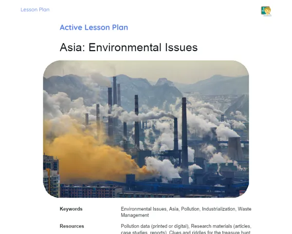
Lesson Plan | Active Methodology | America: Population
| Keywords | population distribution, ethnic origin, poverty in India, major cities, public policies, urbanization, demographic challenges, urban planning, practical application, group discussion, critical analysis, educational games |
| Necessary Materials | blank maps of India, colored markers, specific demographic scenarios, large map of India, representative pieces (schools, hospitals, residential and commercial areas), prior study materials on the Indian population |
Premises: This Active Lesson Plan assumes: a 100-minute class duration, prior student study both with the Book and the beginning of Project development, and that only one activity (among the three suggested) will be chosen to be carried out during the class, as each activity is designed to take up a large part of the available time.
Objective
Duration: (5 - 10 minutes)
Setting clear objectives is essential for directing the lesson. It provides a roadmap for both students and teachers, ensuring that classroom time is used effectively and everyone is aligned with the educational goals. This also allows for evaluating the success of the lesson by checking if the objectives were met.
Objective Utama:
1. Present the distribution of the population across India, highlighting regional differences and the influence of geographic and historical factors on land usage.
2. Analyze the ethnic origins of the Indian population and how they shape the culture and society in various states.
3. Explore the issue of poverty in India, identifying its causes and consequences in different regional and urban contexts.
4. Identify and characterize major cities in India, assessing their roles in the population dynamics and economic landscape of the country.
Objective Tambahan:
- Develop geographic analysis and critical thinking skills related to population data.
Introduction
Duration: (15 - 20 minutes)
The introduction aims to engage students with previously studied content and prepare them for practical activities. By addressing real-life scenarios, students can apply their prior knowledge, promoting analytical thinking. This contextualization emphasizes the relevance of studying India's population, increasing interest in the topic.
Problem-Based Situation
1. Imagine you are a city planner in a bustling Indian metropolis. How would you use population distribution knowledge to create effective public policies?
2. Consider that you are a socioenvironmental researcher examining how population growth impacts environmental sustainability in different parts of India. What demographic factors would you analyze?
Contextualization
The Indian population is incredibly diverse in terms of ethnicity and culture, facing unique challenges and opportunities shaped by its rich history and varied geography. From indigenous tribal communities to megacities like Mumbai and Delhi, each region has its own demographic story. For instance, Mumbai is one of the most populous cities globally, while rural areas in states such as Bihar experience different demographic trends. These real contexts serve to illustrate the importance of understanding human geography in daily life and societal formation.
Development
Duration: (70 - 75 minutes)
The development phase allows students to engage interactively with previously acquired knowledge about India's population. Group work enhances collaboration and communication skills while exploring real and hypothetical scenarios, consolidating their understanding of demographic factors in societal and urban contexts.
Activity Suggestions
It is recommended that only one of the suggested activities be carried out
Activity 1 - 🌎 Mapping Diversity: A Journey Through India
> Duration: (60 - 70 minutes)
- Objective: Analyze and visualize the population distribution and its ethnic diversity in India, discussing the impact on local policy formulation.
- Description: In this activity, students will be divided into groups, each receiving a blank map of India. Their task will be to populate the map with information about population distribution, highlighting areas of high population density and major cities. They should also mark regions of predominant ethnic origins and discuss how this data can influence local policies.
- Instructions:
-
Divide the class into groups of up to 5 students.
-
Provide each group with a blank map of India and colored markers.
-
Ask them to identify and highlight on the map areas with high population density.
-
Request they research their earlier study materials to identify and mark major cities.
-
Identify regions with predominant ethnic origins using different colors for each group.
-
Each group should prepare a brief presentation explaining their map choices and the implications of these distributions.
Activity 2 - 💬 Demographic Debates: Challenges and Solutions
> Duration: (60 - 70 minutes)
- Objective: Develop critical analysis skills and propose solutions for real demographic challenges, fostering debate.
- Description: Students, divided into groups, will receive a specific demographic scenario (e.g., a state with low birth rates and high aging). They will discuss and propose solutions for these demographic challenges, considering aspects like migration and economic policies.
- Instructions:
-
Divide the class into groups of up to 5 students.
-
Assign each group a specific demographic scenario for analysis.
-
Groups will explore possible solutions using demographic data they have studied.
-
Prepare presentations justifying their proposed solutions based on demographic theories and real Indian examples.
-
Organize a debate among groups, allowing them to defend their proposals and critique others.
Activity 3 - 🌆 Populous Cities: The Urbanization Game
> Duration: (60 - 70 minutes)
- Objective: Understand urbanization challenges and develop skills in urban planning considering demographic factors.
- Description: In this engaging activity, students will work in groups to 'build' a city on a large map of India. They will need to consider demographic factors such as population growth and urbanization when deciding where to place educational, healthcare, and residential facilities.
- Instructions:
-
Divide the class into groups of up to 5 students.
-
Provide each group with a large map of India and representative tokens for schools, hospitals, and zones.
-
Explain the need to consider demographic factors when placing their facilities on the map.
-
Groups will discuss the optimal configuration for their city, recording their decisions on another sheet.
-
Each group will present their city to classmates, explaining how their decisions reflect the demographic and urban challenges studied.
Feedback
Duration: (15 - 20 minutes)
This stage aims to reinforce learning, allowing students to articulate their acquired knowledge through practical activities. The group discussion promotes communication skills and provides valuable insights into various perspectives. Additionally, this collective feedback assists in evaluating students' grasp of the topics and the activities' effectiveness.
Group Discussion
At the end of the activities, initiate a group discussion with all students. Start by reinforcing the importance of teamwork and applying knowledge about India's population. Ask each group to share key points and significant findings. Encourage reflections on how population distribution and ethnic diversity impact society and urban planning. Guide the conversation to ensure every voice is heard.
Key Questions
1. What were the biggest challenges you faced applying demographic concepts during the activities?
2. How does the ethnic diversity in India influence local public policies?
3. How can demographic analysis assist in addressing social and urban issues in India?
Conclusion
Duration: (5 - 10 minutes)
The purpose of this conclusion is to consolidate and synthesize the acquired knowledge, ensuring students relate theory to the activities conducted. It highlights the topic's relevance for daily life, encouraging them to view geography as essential for understanding and addressing social and urban challenges.
Summary
In conclusion, we summarize the key points about India's population, including its geographic distribution, ethnic origins, poverty challenges, and urbanization. We review how activities, from 'Mapping Diversity' to 'Demographic Debates' and 'The Urbanization Game,' offered practical applications of the concepts explored.
Theory Connection
Today's lesson linked demographic theory with real-life practices, showcasing how geographic knowledge can be applied to understand and resolve social and urban issues. Students recognized the relevance of studying population trends in urban planning and policy development.
Closing
Finally, we emphasize the significance of population studies in understanding social and economic dynamics in India. This knowledge not only enriches academic learning but also empowers students to actively contribute to community and societal development.